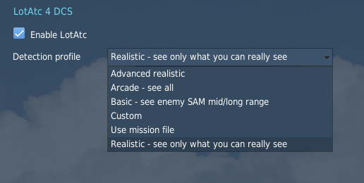
LotAtc features five “Detection Profiles”. The server chooses a profile, that is then enforced for all its LotAtc clients (from both coalitions).
The profile sets what client ATCs will see or not see on their radar displays, and what functionalities will be available to them.
Actually, the LotAtc server knows everything that goes on in the mission. So technically, profiles are sets of ‘filters’, from the least to the most restrictive, applied to data sent to (hence displayed by) LotAtc clients.
Definitions
Detection area
Units equipped with a surveillance radar in DCS have a pre-determined detection area. This area sets “where” the unit can “see” others using its radar. To implement detection areas (range & characteristics), LotAtc 4 DCS uses the needed values directly from DCS’s own database.
This allows LotAtc 4 DCS to manage fluently new units added to DCS World, and keeps the DCS+LotAtc system logical.
Depending on which Detection Profile is set, detection areas may however vary. Please see the description of each Profile below for more details.
The relevant units are:
- AEW(Airborne Early Warning and Control)s aircraft (also known as AWACS(Airborne Warning and Control System)) such as the E-3 Sentry, the E-2 Hawkeye and the A-50 Mainstay.
- EWR(Early Warning Radar)s on the ground.
- Medium and Long Range SAM(Surface to Air Missile)s units.
- Radar-equipped warships such as CV(Aircraft Carrier)s, CVN(Aircraft Carrier, Nuclear-powered)s, CG(Cruiser, Guided Missile)s, CGN(Cruiser, Guided Missile, Nuclear-powered)s, DD(Destroyer)s, FF(Frigate)s, FFL(Frigate, Light)s, FFG(Frigate, Guided Missile), FSG(Corvette, Guided Missile)s… etc.
Those units should be “alive” to have a valid detection area. In other words, if a unit is killed during a mission, then the information its radar provided to LotAtc is lost.
Short range radars, with a detection range of 5,000m or less (based on DCS data) are not taken into account: We consider that only bigger radars are likely to be used by controllers who provide guidance to aircraft.
Radar Coverage
In some of the profiles described below, the notion of radar coverage is used. Your radar coverage is the sum of the detection areas of each of your coalition’s radar assets (provided their detection range is > 5,000m, based on DCS data). Indeed, LotAtc 4 DCS considers that those radar assets work as part of a datalinked network, and that as a controller you’ll be able to see the whole picture.
LotAtc cannot know - at this time - the status (operating/not operating) of the radars. Hence those radars are always considered as active in LotAtc, and always contribute to their coalition radar coverage, except for AWACS that are considered “active” only when above 50 kts (~ 93 km/h) ground speed; this prevents the AWACS to “see” anything when taxying, which would be unrealistic (not to mention the dangerousness for the unlucky engineers around ^^). We’re aware all this is not so cool, and we’ll try to remove this current limitation as soon as possible.
LotAtc Client displays the radar coverage via the detection circles of each of your radar assets. The sum of all circled areas (on your side) is your approximate horizontal radar coverage.
Aircraft’s RCS1 is not taken into account for now. The notion of being inside or outside the radar coverage is a On/Off choice at this time.
The ARCADE profile
The Arcade profile meets two philosophies:
- Being a kind of “god’s eye” (or “cheat”) mode which sees the whole tactical situation, without limitation.
- Being super-easy to use i.e. not all functionalities or options are there.
This profile is intended for beginners or those who don’t care so much about “realism”. It may also be used to stream a full tactical situation to spectators, for people organizing ~live events.
Units displayed in Arcade profile
LotAtc displays all aircraft, ships and ground units (blue & red, airborne & on the ground, even the simple private) on their radar displays, regardless of your coalition or its actual detection capabilities (aka radar coverage).
The only “units” you won’t see on your LotAtc display in Arcade profile are the weapons (missiles of all types, bombs, gun rounds…) that can “fly” but are definitely not considered as aircraft.
Symbology & identification of units in Arcade profile
Aircraft symbology is quite simple: one symbol and color for allied aircraft, another symbol and color for enemy aircraft. That’s all.
Identification of the pilot’s name is provided for all aircraft from both coalitions.
Identification of the unit’s type is provided for all units (aircraft, ground units, boats) from both coalitions.
All those data are automatically provided by LotAtc, from DCS mission data, and cannot be changed within LotAtc in Arcade profile.
The BASIC profile
The Basic profile philosophy is to provide a narrower view of the tactical situation than does the “magical” arcade profile, and at the same time to help controllers with as much automation as possible. It’s intended to be nice to play with, but not too hard to manage for people who want a casual experience about controlling missions.
It introduces a simplified version of the detection area for each surveillance radar equipped unit. We call this simplified version the “Spherical Radar”. It’s based on range only: each radar unit detection area is a sphere, the center of which is the radar location. The sphere is drawn from the max range value for this radar, as set by the DCS database. The Spherical Radar limits LotAtc visibility for aircraft only: Ground and Sea targets may be displayed (if they match criteria) wherever they’re on the map in Basic Profile. This “simulate” a full map ESM capability.
The Basic profile also comes with three important filters. The first two restrict the ability of your radars to see aircraft, while the third one affects your visibility of ground and sea units:
| Units affected | Filter based on | Description |
|---|---|---|
| Aircraft | Speed | This prevents aircraft flying too slowly from being displayed by LotAtc. This allows controllers to declutter the display by not showing aircraft on the ground. |
| Aircraft | Terrain | This prevents aircraft that hide in the relief (terrain masking) from being displayed by LotAtc. |
| Ground/Sea units | Unit’s radar capability | LotAtc simulates an “ESM” capability, meaning that such units will be detected only if they emit a (powerful enough) radar signal. |
The following diagram summarizes the visibility obtained with the Basic profile:
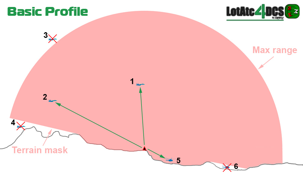
- Airplanes 1 & 2 and helicopter 5 are displayed by LotAtc.
- Airplane 3 is not displayed, even if it flies at the same “horizontal” distance (from the radar) as airplane 2, because being higher it is outside the max range bubble.
- Airplane 4 and helicopter 6 are not displayed, because they’re masked by the terrain.
Units displayed in Basic profile
LotAtc displays:
- all aircraft that:
- have a ground speed > 50 kt for airplanes, and > 25 kt for helicopters. The lower speed for helicopters was introduced to take into account the doppler effect of a rotor as seen by a radar, that helps said radar to detect and classify a chopper even at lower speeds.
- are “seen” by any of your radar assets (taking into account the spherical range of each radar) and the terrain masks in mountainous areas.
- all ground & sea units (anywhere on the map) that:
- possess a radar which detection max range is strictly greater than 5,000m (based on DCS data).
What does this mean? Well, that means that you won’t see a taxying aircraft, nor a hovering helicopter; you won’t see cargo ships, APC(Armoured Personnel Carrier)s or MBT(Main Battle Tank)s either (they have no radar), nor a Shilka for example (it has not enough detection range in DCS, report to DCS encyclopaedia if needed).
Symbology & identification of units in Basic profile
The Basic Profile allows the controllers to use the full extent of the existing symbols in LotAtc 4 DCS. Each controller has the ability to change any aircraft symbol. The assigned symbol is shared among all controllers of the same coalition.
The Basic Profile also aims to help the controllers by automatically assigning certain symbols to certain aircraft (at first detection). Doing this, the software kind of simulates tasks that are mostly done by radar operators IRL.
Table of the 9 symbols available for aircraft in LotAtc 4 DCS Basic Profile
| Relevant coalition: | Symbol name: | Symbol to use for: | Automatically assigned in 0.9.0 for: |
|---|---|---|---|
| Allies or Enemies | Unknown | New contacts for which the controller has no specific information | All aircraft except for AEW(Airborne Early Warning and Control)s (both sides) and allied Helicopters |
| Allies | General - Civilian | Civilian (non-threatening) flights, military freighter under civilian flight rules… | none (WIP) |
| Allies | Helicopter | Allied Helicopters | Allied helicopters |
| Allies | Strike - Support | Allied Bombers (AI, CAS…), Tankers, ASW aircraft… | none (WIP) |
| Allies | Fighter | Allied Fighters in CAP/Air Defense mission | none (WIP) |
| Allies | AEW - HVA | Allied High Value Assets such as AEW(Airborne Early Warning and Control)s, VIP transport… protect them well! | Allied AEW(Airborne Early Warning and Control)s |
| Enemies | Zombie | Suspect or Rogue Civilian aircraft | none - @ controller’s discretion |
| Enemies | Bandit | Enemy military aircraft | Enemy AEW(Airborne Early Warning and Control)s |
| Enemies | Hostile | Enemy aircraft to be shot down | none (WIP) |
Note about the “Helicopter” symbol: IRL, it’s used for allied choppers only. A specific symbol for helicopters does not exist in the “French” set of symbols; hence if you choose “Helicopter” with the “French” set, you’ll visually get the same symbol as General - Civilian. This is not a bug, this is a feature ;)
Note about the “Zombie” symbol: Its use could be extended to (all) civilian aircraft from the enemy coalition: in DCS, there is no real “neutral” or civilian side.
The REALISTIC profile
The Realistic profile represents our best effort to make it feel real. You can’t “see” aircraft outside your radar coverage. The same rule applies for ground and sea targets: we decided to simulate the ESM coverage as equivalent to the radar coverage.
What’s more is that your radar coverage uses what we call the “Full Radar” modelisation, meaning that radar limitations in azimuth and elevation are taken into account. That means for example that an AWACS can’t see just above nor just under itself. As for other values, azimuth and elevation limits applied by LotAtc are directly read from the DCS database.
The following diagram summarizes the visibility obtained against air targets with the Realistic profile:
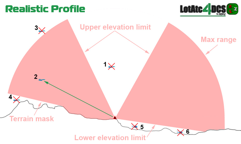
- Airplane 1 is not displayed, because it is above the upper elevation limit of the radar scan zone (aka “blind cone”).
- Airplane 2 is displayed by LotAtc.
- Airplane 3 is not displayed, even if it flies at the same “horizontal” distance (from the radar) as airplane 2, because being higher it is outside the max range bubble.
- Airplane 4 is not displayed, because it is masked by the terrain.
- Helicopters 5 and 6 are not displayed, because they’re under the lower elevation limit of the radar scan zone.
Units displayed in Realistic profile
LotAtc displays:
- all aircraft that:
- have a ground speed > 50 kt for airplanes, and > 25 kt for helicopters. The lower speed for helicopters was introduced to take into account the doppler effect of a rotor as seen by a radar, that helps said radar to detect and classify a chopper even at lower speeds. This declutters the displays at airbases, for aircraft on the ground. This also makes hovering helicopters disappear.
- are “seen” by any of your radar assets (taking into account the Full Radar modelisation) and the terrain masks in mountainous areas.
- all ground & sea units that:
** possess a radar which detection max range is strictly greater than 5,000m (based on DCS data). Reminder: we simulate an ESM capability, not an Air-to-Ground radar. That explains why we did this.
- are “seen” by any of your radar assets (taking into account the Full Radar modelisation) and the terrain masks in mountainous areas.
Symbology & identification of units in Realistic profile
Table of the 9 symbols available for aircraft in LotAtc 4 DCS Realistic Profile
| Relevant coalition: | Symbol name: | Symbol to use for: | Remarks: |
|---|---|---|---|
| Allies or Enemies | Unknown | New contacts for which the controller has no specific information | LotAtc uses this one for each new contact except Allied AEWs |
| Allies | General - Civilian | Civilian flights, military freighter under civilian flight rules… | |
| Allies | Helicopter | Allied Helicopters | No specific symbol exists for helos in “French” set: General - Civilian symbol is displayed instead |
| Allies | Strike - Support | Allied Bombers (AI, CAS…), Tankers, ASW aircraft… | |
| Allies | Fighter | Allied Fighters in CAP/Air Defense mission | Do not use this for fighter/bombers in ground attack missions |
| Allies | AEW - HVA | Allied High Value Assets such as AEW(Airborne Early Warning and Control)s, VIP transport… | Your AEW(Airborne Early Warning and Control)s will get this symbol automatically; that’s the only automatisation in Realistic profile |
| Enemies | Zombie | Suspect or Rogue Civilian aircraft | As there is no real “civilian” side in DCS, this may be used for all enemy transports |
| Enemies | Bandit | Enemy military aircraft | Including enemy AEWs |
| Enemies | Hostile | Enemy aircraft to be shot down | Example: aircraft whose behavior leads you to classify them as threatening fighters |
The ADVANCED REALISTIC profile
It is the same as the REALISTIC one with the following changes:
- All contacts will be Neutral/Unknown at start-up (friend or enemy), you have to select their coalition manually depending on the SITAC (properties panel)
- Friendly contacts do not get their names or types (no name for human pilots)
The USE MISSION FILE profile
When saving a mission file in the mission editor, DCS saves the current LotAtc options in the miz file (all options are concerned: enable, profile, options…). By setting this profile in the DCS server, LotAtc will use the LotAtc options found in the miz.
Make your own with CUSTOM profile
You can make your own profile and setup LotAtc as you want, see the custom profile documentation.
-
Radar Cross Section. A measure of how detectable an object is with a radar. A larger RCS indicates that an object is more easily detected. ↩