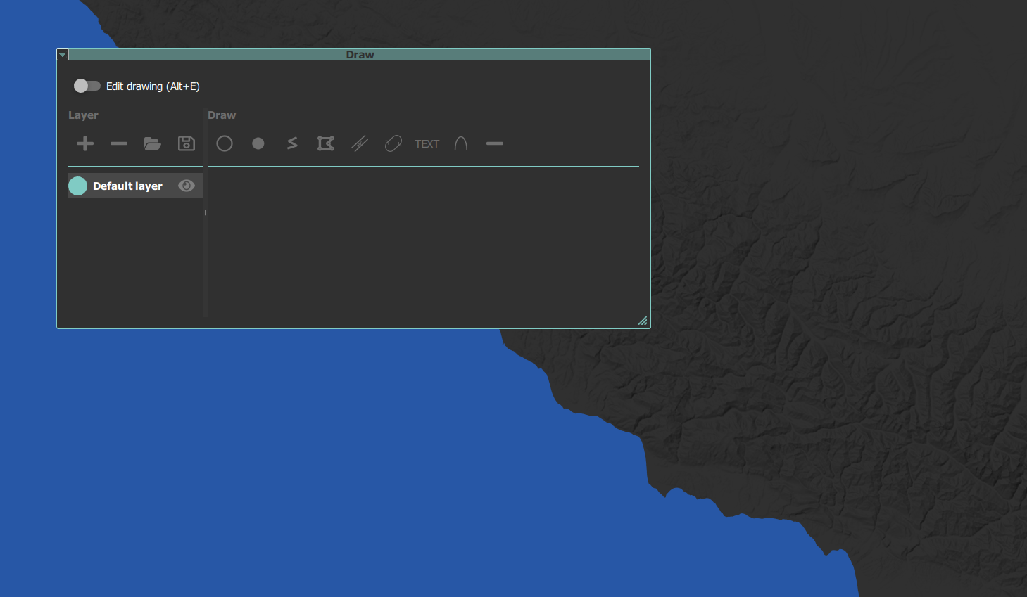
What is it ?
You can draw on the map in LotAtc. It can be used to delimit zones, indicate POI, or anything else…
Available draws:
- Text
- Line
- Polygon
- Circle
With LotAtc Advanced
- Corridor
- Orbit
How ?
On maps view, you can activate draw part in draw tab, then switch on “Edit mode”.
You can make drawings private (only for your eyes) or shared (shared with all friendly coalition controllers).
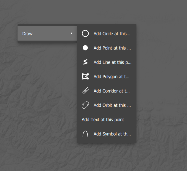
To draw, use left click to begin the drawing.
- Circle: first point is the center, a second click stops the drawing
- Polygon/lines: each left click defines a point, use right click to stop
- Text: use edit to set text
Shared drawings are saved on the server. If you disconnect/reconnect, you will get them. Private drawings are not saved.
A private drawing can be shared later using edit
Use contextual menu by right-click on the map to set a text draw under the cursor (no need to be in edit mode)
Edit draw
Left click on a drawing or select it from the draw list in the draw tab to edit it. Properties depend on the drawing type.
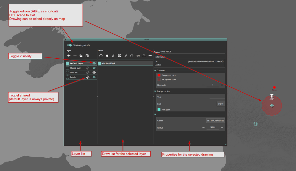
Drawing can be edited directly from the map, in edit mode, just click on edit.
Visibility
Each drawing has a visibility toggle, available from the draw list and from the right-click context menu on the drawing. Hidden drawings stay in the layer (and on disk if shared) but are not rendered on the map. Use it to keep alternates handy without cluttering the picture.
Floor and ceiling altitude (zones)
Zone-shaped drawings (circle, polygon, corridor) accept a floor and a ceiling altitude:
- values are entered in your preferred unit (ft or m) and stored internally in meters,
- a value of
-1(or empty) means not set — the Clear button next to each input resets the value to-1(use this rather than typing-1by hand).0is a valid value and represents ground level, - hovering a zone on the map shows the altitude band, e.g.
FL100-FL300, - the map’s altitude filter uses these bounds: a zone is visible when the filter range intersects
[floor, ceiling]. Zones with no altitude set always pass the filter.
The values only appear in the JSON file when they are set (≥ 0).
Clockwise orbits
Orbit drawings (LotAtc Advanced) carry a clockwise flag that controls the circulation direction of the pattern. Toggle it from the orbit’s properties.
Load / Save
Use the load/save button to load/save all drawings from disk. They will be saved in JSON format, and you are free to edit them.
Add draws automatically at start
If you want to automatically load draws at start, you can use the Saved Games/DCS/Mods/services/LotAtc/userdb/drawings/(blue or red)/*.json files to do so (on the server).
Use the enable item to activate or deactivate the file. You can use files directly by saving in the Draw tab! Just move them to the correct folder.
Files in blue directory will only affect blue coalition controllers. Red for… red…
To only use the file for specific mission, you can add a mission field containing a regular expression:
{
    "author": "me",
    "mission": "lotatc.*",
    "drawings": [
        {
            "author": "",
            "brushStyle": 1,
            "color": "#ffff0000",
            "colorBg": "#33ff0000",
            "font": {
                "color": "#ffb5824d",
                "font": "LotAtc Sans"
            },
            "id": "{0c7ce5ea-1b6c-4e2f-997f-3bbd603ce5af}",
            "latitude": 43.462436190556275,
            "lineWidth": 1,
            "longitude": 42.863763861314595,
            "name": "circle #2995",
            "radius": 56044.85317359681,
            "shared": false,
            "text": "",
            "timestamp": "",
            "type": "circle"
        },
    ],
    "enable": "true",
    "id": "{bb5a86a9-6e84-46cf-b70e-b885a7f089e6}",
    "name": "Default layer",
    "shared": false,
    "timestamp": "",
    "type": "layer",
    "version": "hotfixes/220"
}
In this example, only mission containing lotatc followed by any other character will use this file:
lotatc_missionwill matchmy_missionwill not match
The .* means any character (the .) repeated 0 to infinite times (the *). You can also just put a fixed string like lotatc and it will work.
Regex can be validated with this tool
Draw API
Here is a complete file with all drawing and their properties:
{
    "author": "me",
    "drawings": [
        {
            "author": "",
            "brushStyle": 1,
            "color": "#ffff0000",
            "colorBg": "#33ff0000",
            "font": {
                "color": "#ffb5824d",
                "font": "LotAtc Sans"
            },
            "id": "{0c7ce5ea-1b6c-4e2f-997f-3bbd603ce5af}",
            "latitude": 43.462436190556275,
            "lineWidth": 1,
            "longitude": 42.863763861314595,
            "name": "circle #2995",
            "radius": 56044.85317359681,
            "shared": false,
            "visible": true,
            "floorAltitude": 3048,
            "ceilAltitude": 9144,
            "text": "",
            "timestamp": "",
            "type": "circle"
        },
        {
            "author": "",
            "brushStyle": 1,
            "color": "#ffff0000",
            "colorBg": "#33ff0000",
            "font": {
                "color": "#ff010260",
                "font": "LotAtc Sans"
            },
            "id": "{39da8771-fa48-4ddd-8ee1-a2955cbd2eb0}",
            "latitude": 42.75663984466322,
            "lineWidth": 10,
            "longitude": 42.18261151756428,
            "name": "point #1742",
            "shared": false,
            "visible": true,
            "text": "None",
            "timestamp": "",
            "type": "point"
        },
        {
            "author": "",
            "brushStyle": 1,
            "color": "#ffff0000",
            "colorBg": "#33ff0000",
            "id": "{9adb8609-384d-4be4-af57-11934b98aa48}",
            "lineWidth": 1,
            "name": "line #1153",
            "points": [
                {
                    "latitude": 42.36823170702854,
                    "longitude": 42.50670819716012
                },
                {
                    "latitude": 42.593075043528046,
                    "longitude": 43.03405194719633
                },
                {
                    "latitude": 42.46353426814357,
                    "longitude": 43.717950872937365
                },
                {
                    "latitude": 42.732435188128456,
                    "longitude": 43.98711591204864
                }
            ],
            "shared": false,
            "timestamp": "",
            "type": "line"
        },
        {
            "author": "",
            "brushStyle": 1,
            "color": "#ffff0000",
            "colorBg": "#33ff0000",
            "id": "{7ff58c6e-943a-4ee8-83f6-13139dadc41b}",
            "lineWidth": 1,
            "name": "polygon #2381",
            "points": [
                {
                    "latitude": 42.24635844180599,
                    "longitude": 40.66649823634964
                },
                {
                    "latitude": 41.791329259042726,
                    "longitude": 41.06475263081174
                },
                {
                    "latitude": 42.18736846129762,
                    "longitude": 41.79534345106512
                },
                {
                    "latitude": 42.441242395363616,
                    "longitude": 41.17461591200416
                },
                {
                    "latitude": 42.2260232938033,
                    "longitude": 41.16088300182719
                }
            ],
            "shared": false,
            "timestamp": "",
            "type": "polygon"
        },
        {
            "author": "",
            "brushStyle": 1,
            "color": "#ffff0000",
            "colorBg": "#33ff0000",
            "font": {
                "color": "#ff35c6d7",
                "font": "LotAtc Sans"
            },
            "id": "{e286d343-eb3e-44d9-be1b-0b82da78bd24}",
            "lineWidth": 1,
            "name": "corridor #3266",
            "points": [
                {
                    "latitude": 44.20932705193068,
                    "longitude": 42.05352216199017
                },
                {
                    "latitude": 44.36268874048932,
                    "longitude": 43.682245306611264
                },
                {
                    "latitude": 43.99434327453737,
                    "longitude": 44.62157636128657
                }
            ],
            "radius": 9260,
            "shared": false,
            "text": "Corridor",
            "timestamp": "",
            "type": "corridor"
        },
        {
            "author": "",
            "brushStyle": 1,
            "color": "#ffff0000",
            "colorBg": "#33ff0000",
            "font": {
                "color": "#ff065f17",
                "font": "LotAtc Sans"
            },
            "headingDeg": 103.31841494606454,
            "id": "{1fbcaa1c-820d-4f4d-be07-12043559fe38}",
            "latitude": 43.32272739948711,
            "length": 22851.141026267258,
            "lineWidth": 4,
            "longitude": 44.26177411514135,
            "name": "orbit #1842",
            "shared": false,
            "visible": true,
            "clockwise": true,
            "text": "Orbit",
            "timestamp": "",
            "type": "orbit",
            "width": 9572.000000004353
        },
        {
            "author": "",
            "brushStyle": 1,
            "classification": {
                "classification": "friend",
                "dimension": "air",
                "sub_dimension": ""
            },
            "color": "#ffff0000",
            "colorBg": "#33ff0000",
            "font": {
                "color": "#ffd5b97b",
                "font": "LotAtc Sans"
            },
            "id": "{337dd9cb-c62b-4ea9-abef-fff8c71328ab}",
            "latitude": 43.69324441257426,
            "lineWidth": 10,
            "longitude": 43.92669110735929,
            "name": "symbol #2437",
            "shared": false,
            "text": "None",
            "timestamp": "",
            "type": "symbol"
        }
    ],
    "enable": "true",
    "id": "{bb5a86a9-6e84-46cf-b70e-b885a7f089e6}",
    "name": "Default layer",
    "shared": false,
    "timestamp": "",
    "type": "layer",
    "version": "hotfixes/220"
}