If you want more information about LotAtc 2.0.0, check the LotAtc 2.0.0-alpha1 post here
Stable version with 2.0.0 is coming, here is a first release candidate!
RC1 is NOT compatible with previous beta
I have to make a modification in network communication that breaks retro compatibility of betas, the next 2.0 will be compatible with this version as I have detailled in this post.
Installer has changed, see complete details on this post especially if you have 2.0.0-beta installed !!!
See the migration guide for 1.x to 2.x
Continue to send me feedback on Discord or by mail to help me to make it better and more stable! Thanks !
Next ?
- Continue to focus on bugfixes for this version to be able to release it as stable ASAP! So I will certainly releasing some patches in next days/weeks
- Start work on next minor version 2.1 with some great thinks like better drawing, datalink management..
- Finalize LotAtc Generator and Advanced
- more…
Download:
Click to see the changelog for LotAtc 2.0.0-rc1...
Changes since 2.0.0-beta4
Client
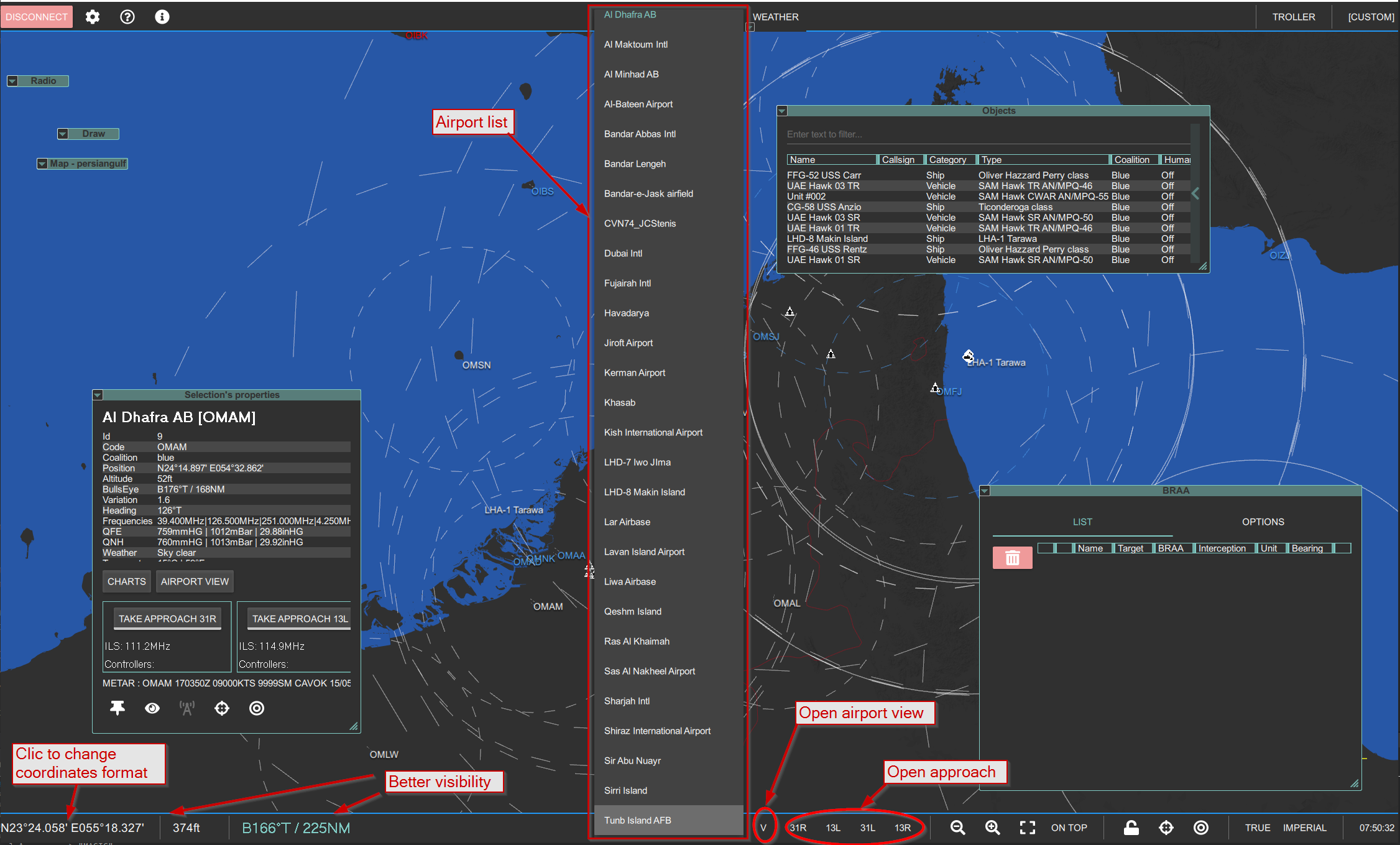
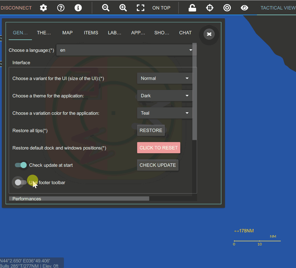
Add footer bar in LotAtc, lot of rework of UI around that
- Make coordinates and bulls more visible
- Click on coordinates change coordinates format
- When clicking on airport, auto-select it in footer bar and add fast access to airport view and approaches
- Can be disabled
Rework all dialogs
Add close button to approaches dialog
Better relief layer (smaller/faster)
Better map tiles loading
Airports list are now sorted
Better default zoom for maps and airport view
Add target type in BRAA list
Automatically centers view on bulls when connecting
Fix BRAA troubles in BRAA list
Fix weather dialog
Fix controller list display
Fix troubles with bullseye management
Fix radio tower position (was on ground…)
Fix measure line label under labels
Fix troubles with coordinates in lon/lat HMS decimales
Fix heading in properties not following bearing mode (true/mag)
Fix last map loading at startup
Server
Add option to send DCS chat on LotAtc controller connect/disconnect
Add option to define airport radar mode (nothing, radar ground/air, radar ground/ground..)
- See config.lua
Fix for ground speed management
Fix transponder mode2/mode4 errors
Fix ground units detection with airport
Common
Add auto update alert in client (options > general)
Add installer auto-update (to update LotAtc_updater itself)
Modify relief/maps/charts paths see the article here
Fix installer that does not store path when directly modified in the field
Fix installer shortcuts
Fix installer saved games directory not correctly found after changed
___
Next is the same than 2.0.0-beta3:
Client
Add airport view, you can see aircraft on taxiways now (“airport view” button on airport properties dock)
- Display aircrafts with top view symbol on airport even if not moved
- Complete modelisation of airport with parking, taxiways labelised, currently status:
- Caucasus is fully available
- PG is WIP (Iran airports missing, no taxing names yet)
- Nevada will come in later version
[Advanced] Add theme support: you can load/save theme and switch themes easily
Theme contains:
- maps colors
- layers colors/opacity
- Symbology
Add SRS support (need last SRS version)
In LotAtc:
- Open Radio dock
- Select SRS, then activate
- Choose a location (airport, AWACS…)
See SRS Discord for more help!
Thanks Ciribob!
[Advanced] Add server admin commands
If enable in config.lua you will be able to pause/unpause/stop the mission directly from LotAtc client
Add opacity slider for filtered objects
All settings are now saved in %appdata% directory (Users directory), no more in register
User can export/import settings
Add toggle mode for measure line, first click will start measure, then just move the mouse to get a BRA, click again to hide it
Add context menu on map
Integrate airports view for all airports on Nevada and Persian Gulf
Add automatic switch on airport display (name or code), following zoom value
Can use approach views on airport view and/or on tactical view
Show total map width with scale on bottom right
Transponder IFF simulate Mode 1, 2, 3, S (4 and 5 are coming)
Server side licenses ALLOWS airport view also
Add side/symbol changes on context menu over an item
Add type’s object editable for all items (only if show_datas is false)
Add option to display Bulls data with BRA on measure line
Integrate Papi’s FLIP with its agreement into LotAtc for Caucasus and Persian Gulf (click on charts button on airport’s properties). BIG THANKS TO PAPI !!!!
Add option to hide airport view items in tactical view (map dock > options)
BRAA text can be displayed on source/center/target now
Add option to filter no moving aircrafts in objects panel
Dock management update
- Single click to open/close dock
- Ctrl+click to maximize/restore
- Shift+click to maximize/minimize
Label management update
- Label overlap can be customized (nothing, hide on overlap, increase distanse, increase angle…)
- Label still be rotated manually by shift+clmick or shift+ctrl+click
Update maps, layers for Caucasus, Nevada, PersianGulf
Optimisation in map loading
Show server pause status
Dark theme is now the default one
Approach is now available in airport view
Lots of cosmetics
BETTER PERFORMANCES
Table columns can be resized and autoresize
Add settings for BRAA line and measure line font size
Add bulls to measureline
Better performances on item display
Better performances on label display
Rework labels for ships/ground
- All tables are faster and 4k friendly
- Fix too much updates in some cases
- Better texture management on map display
- Label management is faster and no more blocking display
Better IDENT mode display
Better radar list display (mono radar mode selection and radio radar selection)
Add transponder mode label (can only display mode 1,2,3,S…)
Busy indicator on top right show maps loading activity
Add tips in some place to help to use LotAtc more efficiently (more to come)
autocompletion for aircrafts/helicopter on type combobox (based on available symbols)
Lot of fixes for dock/tab: click on it pull on top, void tab, empty dock…
Rotate/increase label management refine, support custom rotation, realign in item heading if possible
Layers setting (color/opacity) badly saved/load sometimes
Fix some crash with maps loading
Fix winds display in weather
Fix table display that not follow font size
Better HiDpi display (4K)
Fix UniversRadio ID on airports
Lots of fixes…
Fix properties are shown on spotting element (need to have a track to get data)
Fix maps/airport install
BRAA management fixed
- Better display in list
- Add quick del button
- Change more easily unit and bearing mode for each BRAA from the list
- Fix BRAA from/to bulls
Fix crash with type label
Fix not correct version not shown correctly when try to connect to a server not compatible
Fix dynamic dock (approach, properties…) not correctly close when disconnect
Fix coalition not correctly managed in connection dialog
Fix coalition changes on item not always displayed
No more ATIS management for SRS (only available with UniversRadio)
Fix server pause status display
Remove Alt+click to add draw, use right click (contextual menu) now to do so
Fix in approach view
Ground filter remove aircraft on friend airports
Fix BRAA/Context menu bad interaction
Fix carrier options are no displaying
Fix label management blinking in distance/rotation
Fix label manual rotation (disabled in rotate/increase distance mode)
Do not display airport view in airport view selection’s properties… inception button…
Fix detection/threat opacity settings in options > map is not working correctly
Fix SRS LOS
Fix SRS/UR UDP troubles
Fix delete draw delete everything
Fix speed line stay longer with stationnary (not yet perfect, there are still displayed in first second)
Fix missile type display
Fix Cannot zoom with mouse over an item
Fix make right side of approach and object panel resizeable
Fix IDENT not INDENT typo
Fix map is no more display after zoom in/out
Fix type not always modifiable/displayed correctly
Fix objects dock/approach dock open/close item behavior on resizing
Fix Bullseye properties
Fix crash if no map installed
Add limit option for type block in labels %(type|5) will limit type to 5 characters
Server
Rework of radar modelization
- 2 modes:
- Global: all available radars make the total radar coverage as in LotAtc 1.X
- Monoradar (WIP): Each controller will have to choose the radar to use, it will get only contacts from this one (later coverage will be completed by datalink simulation)
- Add RCS simulation: all items (planes, heliccopters, missiles…) will be computed and displayed if radar can see it using their RCS resolutaion and item own RCS
- Add Radar resolution : if enabled, radar will not see items near each other, only one track could be made ( for example 3 aircrafts separated by 20m will be seen as only one contact)
- Add spot/track management : radar will first see a spot with no data, then after a while (for example 6s, could be csutomized) if the spot is always there, a track will be made on it (and have data as speed, hedaing, symbol…)
All theses options can be enable/disable in profile lua file (see profile/custom.lua for more help).
Better support for dedicated server
- Enable dedicated_mode in config lua
- No more need to edit Config/Options.lua
- Put your licenses in Saved Games/
/LotAtc Data/Licenses/ In config.lua, enable dedicated_mode, no more need to edit Config/options.lua, just install LotAtc mods now in dedicated saved games directory
Add more control to controllers login
Server admins can now:
- Blacklist/Whitelist Ips (there is still some troubles with IP6 support)
- Add specific username/password that will be authorized to connect with LotAtc
- Enable/disable old login way by standard passwords (blue/red one)
Add quick mission in DCS to use LotAtc with test mission
Administrator can customize config.lua with config.custom.lua file
- See config.lua :
Server commands only available to specific users
- See server commands :
Add SRS Transponder support (nothing to do, just activate LotAtc transponder settings on SRS Server)
Fixes enemy type not correctly reset in realistic mode
When no controllers are connected, footprint of LotAtc server (CPU/RAM) have been reduced
Update internal librairies
New client connected received all units at start quickly
RCS management is now working correctly
With neutral coalition by default options, no more data will be display for :
Better performances on server update, DCS is no more blocking by LotAtc, all is now correctly multithreading
- Detection/threat range for ENI
- Type for ENI ship/sams
- Callsign for ENI ship/sams
When no relief installed, radar see nothing, now it will see as terrain is plate
Fix bad detection status in some cases
Fix crash when using mono-radar simulation
Add vcredist in OvGME package
Fix chat always blocked in chat_filter set to void
Fix magvar not deployed
Fix AI’s transponder from DCS Mission editor
Fix transponder mode4 management
Lots of fixes…
Common
Add compression on network exchange
Callsign support
User directory has been renamed from C:\Users\you\LotAtc 4 DCS Data\ C:\Users\you\LotAtc Data</span>
New installer
Fix latence on network transmission
Performances increase in relief management
Rework log timestamp format (same than DCS, easy for log merge tools)
Magnetic values are take care of year of the mission (data from 2010-2025, 2010 if outside this window)
Update graphics/system librairies
New installer (beta)
If you have already install LotAtc 2.x, you can update directly from your computer:
- In LotAtc Client, Go in
Options > General > Check update - Launch
LotAtc/Update LotAtcfrom startup menu - Launch
LotAtc_updater.exefrom LotAtc Client install dir (default: `C:\Program Files\LotAtc’)
It is a beta version, consider it as UNSTABLE If you want something stable, use the stable version
Download LotAtc Installer - 64 bits - (EXE)